

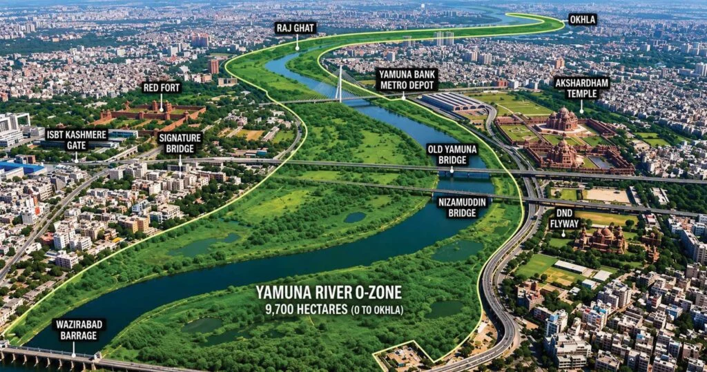
On a warm morning in early June 2026, Mohammad Imran stood beneath a green-and-white signboard fixed to a boundary wall near his home in Abul Fazal Enclave, Okhla. He had lived there for more than two decades. His children had grown up in that house. He had paid for its construction in instalments, watched a drainage line laid in front of it by the Delhi government, voted from its address for three decades of elections. He had never thought of himself as a squatter.
The signboard changed something. It bore the words ‘O-Zone’. Below that, in smaller Hindi text, it warned of restrictions on construction. Imran had no idea what O-Zone meant. But a neighbour had forwarded a WhatsApp message warning that demolition was coming. Someone else in the lane said it was all a political conspiracy. A third person said the Delhi High Court had ordered everything to be cleared. None of these claims was fully accurate. All of them were believed by somebody.
On a visit to the lane in late May, a neighbour stopped Imran mid-conversation to show a screenshot on his phone – a blurry photograph of a purported DDA demolition list circulating in a local WhatsApp group, bearing street names that matched no identifiable locality in Okhla. It had been forwarded three hundred times. Nobody had verified it. It was fabricated. This small episode captures something important: in the absence of clear official communication, fear does not wait for facts to catch up.
This scene – one man, one signboard, one street full of competing rumours – is a microcosm of what has unfolded across Okhla, Shaheen Bagh, Batla House, Jaitpur, Khadda Colony and dozens of adjoining localities over recent months. The O-Zone debate has grown into one of the most significant urban planning controversies in contemporary Delhi. It sits at the intersection of environmental law, housing insecurity, colonial-era land records, administrative failure, political mobilisation and deep community anxiety.
On June 10, 2026, Delhi Chief Minister Rekha Gupta attempted to draw a line under the immediate crisis by declaring publicly that no existing structure in the city’s O-Zone areas would be demolished. It was the most direct and senior political statement on the matter to date. It calmed some fears. It left others intact. And it raised questions that neither a press conference nor a WhatsApp forward could easily answer.
What Is the O-Zone?
The term ‘O-Zone’ in Delhi’s planning vocabulary refers to what was designated in successive Master Plans as the ‘Zone O’ or the Yamuna River Zone.
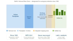
Caption:What is the O-Zone? – A spatial explainer showing the river, floodplain, contested mapping zone, and settled city. The amber overlay on the “contested boundary” is the visual argument of the entire piece: the map and the ground don’t match. The four fact tiles at the bottom give readers the key numbers without a wall of text.
It broadly encompasses the floodplain of the Yamuna – the land adjacent to the river that is periodically inundated, that recharges groundwater, that provides natural drainage, and that historically served as an ecological buffer between the river and the expanding city.
Delhi’s Master Plans, beginning with the 1962 plan and continuing through the Master Plan for Delhi 2021, designated the Yamuna floodplain as a zone requiring special restrictions. The logic is both ecological and practical. Floodplains absorb monsoon flood surges, preventing them from inundating residential and commercial areas. They recharge the city’s depleted aquifers. They sustain biodiversity along what is one of India’s most ecologically stressed river systems. Construction on floodplains has been associated, globally and locally, with increased flood risk, groundwater depletion and long-term urban vulnerability.
Under the Master Plan for Delhi 2041, which is now operative, the Yamuna floodplain is designated for ecological restoration, not urban expansion. The plan envisions the river corridor as a green lung for the city, with restrictions on new construction, commercial development and permanent structures within its boundaries.
The O-Zone, in formal planning terms, is therefore an environmental protection designation. The problem is that its boundaries have never been perfectly fixed, widely understood or consistently enforced.
“The O-Zone boundary as it appears on DDA planning maps is partly a historical artefact, not a precise ecological survey. Parts of what is designated Zone O in south-east Delhi have been continuously settled and serviced for thirty to forty years. When you overlay a 1960s floodplain map on a 2026 residential neighbourhood, you are not doing ecology – you are doing bureaucracy. Those are very different things.”
– Prof. Sanjay Kumar Srivastava, School of Planning and Architecture, Delhi (interview, May 2026)
How Did Okhla Get Here? The Making of a Planning Paradox
To understand why Okhla is the epicentre of this debate, one must go back several decades – to the waves of migration that transformed Delhi’s south-eastern margins from agricultural and riverine land into one of the city’s most densely populated urban belts.

Caption:From planning to crisis – the timeline – Six events from 1947 to June 10, 2026 on a single spine. Colour-coded: blue for planning decisions, green for state endorsement, red for demolition events and danger, amber for the ambiguous present. The 2026 CM statement is set in red to signal it’s a response to crisis, not a resolution of it.
The partition of 1947 set off the first major population displacement into Delhi. Subsequent decades brought waves of internal migration from Uttar Pradesh, Bihar, Rajasthan and other states, as people sought economic opportunity in the capital. The eastern and south-eastern stretches of Delhi – closer to the Yamuna, cheaper to settle, farther from formal civic planning – became natural destinations for those who could not afford formal housing.
By the 1970s and 1980s, what had been vacant or agricultural land near the Yamuna had begun to fill with informal settlements. Local politicians facilitated the process, recognising that electoral constituencies were being built. Government services like water connections, electricity, schools, ration shops followed settlement. With every municipal election, every voter list revision, every utility connection issued, the state tacitly acknowledged the existence of these populations.
The colonies that now fall within or near O-Zone boundaries did not spring up overnight in defiance of the law. They grew incrementally, over decades, with the implicit or explicit toleration of successive governments. Imran and thousands like him bought plots from sellers who themselves had bought from earlier settlers. Title chains are murky. Land records are contested. But the lived reality – brick homes, paved lanes, functioning drains – is not.
Haji Maqsood, a 67-year-old retired government clerk who has lived in Jamia Nagar since 1986, frames the contradiction in terms that are impossible to argue with. “I applied for a government job in 1981. I gave the state my entire working life. I built this house from my pension and my savings. My three sons were going to inherit one floor each – that was the plan for the family. Now someone puts up a board and says my house is in an environmental zone. Which environment? The government built the road to this house. The government gave me water. The government built a school for my grandchildren 50 metres away.” He paused. “If they wanted to protect the environment, they had 40 years to tell me.”
The PM-UDAY Complication
The Pradhan Mantri Unauthorised Colony in Delhi Awas Adhikar Yojana, known as PM-UDAY, was launched by the UnionGovernment in 2019. Its stated purpose was to provide ownership rights to residents of Delhi’s estimated 1,731 unauthorised colonies. The scheme recognised a political and humanitarian reality: that hundreds of thousands of families lived in legal limbo, owning structures but lacking title to land.
PM-UDAY was broadly welcomed across affected communities. It promised a pathway to regularisation, to legal title, to security. Many residents in Okhla believed their colonies would be included. Some began the documentation process. Others held back, waiting to see how the scheme developed.
What PM-UDAY did not, and legally could not, do was override environmental designations. Colonies within the Yamuna floodplain, or those that fell under O-Zone classifications, faced a distinct legal complication. Environmental regulations and court orders pertaining to the Yamuna operate as a separate tier of law, not easily overridden by administrative regularisation schemes.
The result has been confusion, disappointment and, in some cases, a sharpening of fears. Residents who expected that PM-UDAY would resolve their legal status find themselves instead facing O-Zone notices. The exclusion of some colonies from regularisation lists, or the ambiguity about which localities qualify, has generated precisely the anxiety that the scheme was meant to alleviate.
The Law: What Regulations Actually Say
The O-Zone debate involves an overlapping architecture of law, regulation and court order that even informed citizens find difficult to navigate. Simplification is necessary, but so is accuracy.
The Master Plan Provisions: Delhi’s successive Master Plans, prepared by the Delhi Development Authority (DDA), have consistently designated the Yamuna floodplain as a zone in which residential construction is either prohibited or heavily restricted. The Master Plan for Delhi 2041, approved following an extensive process of public consultation and technical review, reaffirms this position. It envisions the Yamuna RiverZone as an ecological corridor and restricts new construction within it.
However, the Master Plan does not specify, with exact GPS coordinates, which plot in which colony falls within the O-Zone. Boundary interpretation has always required reference to planning maps, and those maps have not always been updated to reflect ground realities or technical corrections.
The Delhi High Court: The Yamuna floodplain has been the subject of sustained judicial attention. The Delhi High Court, exercising its jurisdiction over environmental matters, has passed numerous orders over the years, directing the removal of encroachments from the riverbed and floodplain, the preservation of ecologically sensitive areas, and the enforcement of construction restrictions.
These orders are legally binding on government agencies. They create obligations that administrative schemes like PM-UDAY cannot simply set aside. When DDA officials or municipal authorities act on O-Zone matters, they are frequently responding to court-mandated requirements rather than purely executive policy choices. This legal context is often missing from community-level discussions, creating the impression that demolition drives or construction bans are arbitrary political decisions rather than court-directed actions.
It must be said clearly: court orders pertaining to the Yamuna floodplain have not uniformly targeted any particular community. They have been applied, with varying degrees of consistency and completeness, across multiple localities along the river, including areas with different demographic profiles. The selective perception of enforcement – real as it may be as a community experience – must be distinguished from the formal legal position.
The Agra Canal Argument: One of the most contested technical arguments in the O-Zone debate concerns the boundaries of the floodplain as historically demarcated. Local representatives, RWA leaders and several community advocates have argued that portions of Jamia Nagar, Abul Fazal Enclave and Shaheen Bagh were incorporated into O-Zone designations partly because of how the Agra Canal, a historic irrigation channel running through south Delhi, was treated in planning maps.
The argument, stated briefly, is this: that the area between the Agra Canal and the Yamuna was historically considered riverine or floodplain land, but that over time, as the city expanded and the canal functioned as a boundary marker, some localities that were genuinely settled urban areas came to be mapped within the O-Zone, not because they were ecologically part of the floodplain but because of planning map conventions that were never subsequently corrected.
Whether this argument is technically valid is a matter that requires formal adjudication by courts, DDA and environmental authorities. It has not yet been definitively resolved. But it is not a fringe argument. It has been raised by MPs from multiple parties, including Manoj Tiwari of the BJP, who has stated publicly that certain areas shown as O-Zone may not accurately reflect current geographical or ecological realities.
“Many areas shown as O-Zone are there due to historical mapping errors and need correction.” – Manoj Tiwari, MP, North East Delhi
The June 10 Assurance: What It Says, What It Does Not
On June 10, 2026, Delhi Chief Minister Rekha Gupta chaired a high-level meeting on the O-Zone controversy. The gathering included senior DDA officials, Members of Parliament from affected constituencies and other stakeholders. Following the meeting, Chief Minister Gupta made a public statement that immediately became the most significant political intervention in the debate:
“No existing structure in the city’s O-Zone will be demolished.”– Delhi Chief Minister Rekha Gupta, June 10, 2026
The Chief Minister further clarified that the authorities’ primary concern was with ongoing or new construction within protected areas, not with structures that had already been built. She acknowledged the growing anxiety among residents and directed authorities to review the placement of O-Zone warning signboards that had reportedly triggered panic in several localities.
For residents like Imran, standing beneath a green signboard in Abul Fazal Enclave, this was the first unequivocal assurance from the highest office in Delhi’s government. It was received with relief, often audible relief, in the tea stalls and alleyways of Okhla.
Scan to read
full article